About Westport Harbour
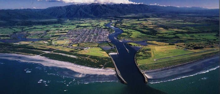
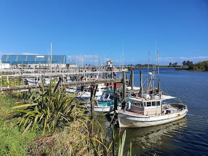
Westport Harbour (Kawatiri) is a working river port located at the mouth of the Buller River on the West Coast of New Zealand’s South Island. It is primarily a commercial and fishing harbour but also accommodates visiting recreational vessels. This is a bar harbour, and conditions at the entrance can change quickly due to swell and river flow. Careful planning is required before entry. Entering the Harbour (Yachts & Recreational Vessels) Important The harbour entrance crosses a river bar. Entry may be restricted in heavy swell or adverse weather. Contact the Harbourmaster before arrival for current bar conditions. Monitor local VHF channels for traffic and instructions. Harbourmaster – Westport Phone: +64 3 788 8168 VHF: Channel 14 (confirm locally before arrival) Operated by: Buller District Council (Advance contact is strongly recommended for yachts unfamiliar with the bar.) Westport Harbour is not a full-service marina, but it does provide practical facilities for visiting yachts. Berths Fishing and commercial berths Limited space may be available for visiting recreational vessels No large dedicated floating marina complex Available Amenities Fresh water supply Shore power (limited availability) Waste oil disposal Harbourmaster services Basic wharf access Nearby Services (within town) Fuel stations (not always dockside) Groceries and supplies in Westport township Marine engineering services (limited) Restaurants and accommodation nearby Westport Harbour is a small commercial river port that accommodates fishing vessels and limited recreational craft. While not a purpose-built marina, it offers essential services for yachts able to safely cross the bar entrance. Advance communication with the Harbourmaster is essential due to changing sea conditions. Kawatiri Specifications Trailing Suction + Grab Twin Screw Length 55m 915 Gross Tons Bow Thruster 200 BHP Hopper Capacity 635m3 Dredging Depth 10.5m CD, Grab Depth 15m CD Loaded Draft 4.1m Available at the Port: Harbour Master services Berths for fishing and leisure vessels. Fresh water, power, and waste oil disposal.
Facilities
Port Information
Telephone
Berth Sizes
Depth at MLW
Manoeuvrability
Channel Marking
VHF Channel
Port of Entry
Overseas Visitor Berths
Catamaran Berths
Dock Type
Tidal Flow
Active Winter
Weather Forecast
 SE 6–8 knots.
 6 to 10°C
 SW 1.2m at 9s period
 UV Index: 0 - Low
 Sunny
Sunny
- SE 8 knots decreasing to 5 knots.
- Increasing from 9 to 15°C
- SW 1.2m at 9s period
- UV Index: 1 - Low
- Sunny
- Light and variable.
- Decreasing from 15 to 12°C
- W 1.2m at 10s period
- UV Index: 0 - Low
- Sunny