Recreatiepark Jachthaven De Lunenburg
Facilities & Weather Forecast
![Marina Image](https://d3mc2wqt0g7xc3.cloudfront.net/media-test/point21443.jpg)
Recreatiepark Jachthaven De Lunenburg
Marina in The Netherlands
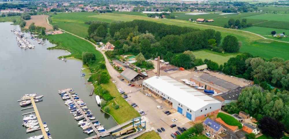
Our water sports company is located in the former Lunenburgerwaard brick factory in Wijk bij Duurstede, a quiet area on the dead arm of the Rhine river. The historic town of Wijk bij Duurstede is easily accessible from the port. The marina offers space for 190 permanent moorings and 40 temporary moorings. All jetties are equipped with electrical outlets and drinking water. The marina offers vari
Show More
Recreatiepark Jachthaven De Lunenburg Servizi
Elettricità
Acqua
Wifi
Docce
Acque Reflue
Toilette
Riciclaggio
Cibo
Biciclette
Costruttore di Barche
Alaggio
Strutture Mediche
51.97461 N, 5.36543 E
Recreatiepark Jachthaven De Lunenburg Information
Comunità Attiva in Inverno?
Yes
Manovrabilità
Fair
Approcci e Segnalazione dei Canali
Fair
Tipo di Molo
Floating
Profondità alla Bassa Marea Media
2 - 3m
Corrente/Flusso di Marea
Negligible
Porto di Entrata
No
Ormeggi per Visitatori
Yes
Telefono
+31343577743Recreatiepark Jachthaven De Lunenburg Weather Forecast
Sun
1PM - 5PM
16 February 2025
- E 11 knots decreasing to 8 knots.
- 2–4°C
- Sunny
Sun
5PM - 9PM
16 February 2025
- E 5–10 knots. Gusts up to 21 knots.
- −1–2°C
- UV Index: 0 - Low
- Sunny
Sun
9PM - 5AM
16 February 2025
- E 5–7 knots. Gusts up to 20 knots.
- −5–−1°C
- UV Index: 0 - Low
- Sunny
Mon
5AM - 9AM
17 February 2025
- E 6 knots.
- −4°C
- UV Index: 0 - Low
- Mostly fine
Mon
9AM - 1PM
17 February 2025
- E 6 knots.
- Increasing from −3 to 2°C
- UV Index: 1 - Low
- Sunny
Mon
1PM - 5PM
17 February 2025
- E 5–7 knots.
- 2°C
- UV Index: 0 - Low
- Sunny
Mon
5PM - 9PM
17 February 2025
- E 5–7 knots. Gusts up to 18 knots.
- −2–1°C
- UV Index: 0 - Low
- Sunny
Mon
9PM - 5AM
17 February 2025
- E 6 knots. Gusts up to 17 knots.
- −4–−2°C
- UV Index: 0 - Low
- Mostly fine
Tue
5AM - 9AM
18 February 2025
- E 6–8 knots. Gusts up to 18 knots.
- −4°C
- UV Index: 0 - Low
- Partly cloudy
Tue
9AM - 1PM
18 February 2025
- E 8 knots increasing to 10 knots. Gusts up to 17 knots.
- Increasing from −3 to 3°C
- UV Index: 1 - Low
- Mostly fine
Tue
1PM - 5PM
18 February 2025
- E 8–12 knots. Gusts up to 18 knots.
- 2°C
- UV Index: 0 - Low
- Mostly fine
Tue
5PM - 9PM
18 February 2025
- E 8–10 knots. Gusts up to 25 knots.
- −1–2°C
- UV Index: 0 - Low
- Mostly fine
Tue
9PM - 5AM
18 February 2025
- E 8–11 knots. Gusts up to 26 knots.
- −5–0°C
- UV Index: 0 - Low
- Partly cloudy
Wed
5AM - 9AM
19 February 2025
- E 10 knots. Gusts up to 26 knots.
- −6–−1°C
- UV Index: 0 - Low
- Cloudy
Wed
9AM - 1PM
19 February 2025
- SE 9–12 knots. Gusts up to 24 knots.
- Increasing from −2 to 4°C
- UV Index: 0 - Low
- Cloudy
Wed
1PM - 5PM
19 February 2025
- SE 11 knots decreasing to 9 knots. Gusts up to 19 knots.
- 4°C
- UV Index: 0 - Low
- Cloudy
Wed
5PM - 9PM
19 February 2025
- SE 7–9 knots. Gusts up to 24 knots.
- 1–4°C
- UV Index: 0 - Low
- Cloudy
Wed
9PM - 5AM
19 February 2025
- SE 7–9 knots. Gusts up to 22 knots.
- 1–4°C
- UV Index: 0 - Low
- Cloudy
Thu
5AM - 9AM
20 February 2025
- S 8 knots. Gusts up to 21 knots.
- 1–4°C
- UV Index: 0 - Low
- Cloudy
Thu
9AM - 1PM
20 February 2025
- S 8–10 knots. Gusts up to 22 knots.
- Increasing from 4 to 9°C
- UV Index: 1 - Low
- Cloudy
Thu
1PM - 5PM
20 February 2025
- S 8–10 knots. Gusts up to 21 knots.
- 9°C
- UV Index: 0 - Low
- Cloudy
Thu
5PM - 9PM
20 February 2025
- S 8–11 knots. Gusts up to 28 knots.
- 7–10°C
- UV Index: 0 - Low
- Cloudy
Thu
9PM - 5AM
20 February 2025
- S 8–12 knots. Gusts up to 26 knots.
- 7–11°C
- UV Index: 0 - Low
- Cloudy
Fri
5AM - 9AM
21 February 2025
- S 8–14 knots. Gusts up to 26 knots.
- 10°C
- UV Index: 0 - Low
- Cloudy
Fri
9AM - 1PM
21 February 2025
- S 9–16 knots. Gusts up to 26 knots.
- Increasing from 10 to 13°C
- UV Index: 0 - Low
- Cloudy
Fri
1PM - 5PM
21 February 2025
- S 10–16 knots. Gusts up to 24 knots.
- 11–14°C
- UV Index: 0 - Low
- Cloudy
Fri
5PM - 9PM
21 February 2025
- S 13 knots decreasing to 10 knots. Gusts up to 25 knots.
- 10–12°C
- Chance of showers
Fri
9PM - 5AM
21 February 2025
- S 10 knots decreasing to 7 knots. Gusts up to 23 knots.
- 9–11°C
- Chance of showers
Sat
5AM - 9AM
22 February 2025
- S 7 knots increasing to 10 knots. Gusts up to 22 knots.
- 8°C
- Cloudy
Sat
9AM - 1PM
22 February 2025
- SW 10 knots increasing to 12 knots. Gusts up to 20 knots.
- 8–13°C
- Cloudy
Sat
1PM - 5PM
22 February 2025
- SW 10–13 knots. Gusts up to 20 knots.
- 9–13°C
- Cloudy
Sat
5PM - 9PM
22 February 2025
- SW 10 knots decreasing to 6 knots. Gusts up to 20 knots.
- 6–11°C
- Chance of showers
Sat
9PM - 5AM
22 February 2025
- SW 5–10 knots. Gusts up to 21 knots.
- 5–8°C
- Cloudy
Sun
5AM - 9AM
23 February 2025
- SW 6–10 knots. Gusts up to 21 knots.
- 4–7°C
- Cloudy
Sun
9AM - 1PM
23 February 2025
- SW 8 knots increasing to 13 knots. Gusts up to 22 knots.
- Increasing from 6 to 10°C
- Cloudy
Sun
1PM - 5PM
23 February 2025
- SW 11–14 knots. Gusts up to 23 knots.
- Increasing from 11 to 14°C
- Cloudy
Sun
5PM - 9PM
23 February 2025
- SW 10–18 knots.
- 9–12°C
- Chance of showers
Sun
9PM - 5AM
23 February 2025
- SW 14 knots decreasing to 12 knots. Gusts up to 31 knots.
- 11°C
- Chance of showers
Mon
5AM - 9AM
24 February 2025
- SW 9–16 knots.
- 9°C
- Chance of showers
Mon
9AM - 1PM
24 February 2025
- S 9 knots increasing to SW 13 knots. Gusts up to 29 knots.
- 10°C
- Chance of showers
Mon
1PM - 5PM
24 February 2025
- SW 12–15 knots. Gusts up to 29 knots.
- 10°C
- Cloudy
Mon
5PM - 9PM
24 February 2025
- SW 9–13 knots.
- 9°C
- Cloudy
Mon
9PM - 5AM
24 February 2025
- S 5–21 knots veering W 5-21 knots. Gusts up to 29 knots.
- 8–12°C
- Cloudy
Tue
5AM - 9AM
25 February 2025
- 4–10 knots.
- 7°C
- Chance of showers
Tue
9AM - 1PM
25 February 2025
- SW 4 knots increasing to 9 knots.
- 8–10°C
- Cloudy
Tue
1PM - 5PM
25 February 2025
- S 10 knots.
- 10°C
- Cloudy
Tue
5PM - 9PM
25 February 2025
- 6–9 knots.
- 5–10°C
- Mostly fine
Tue
9PM - 5AM
25 February 2025
- S 4–11 knots. Gusts up to 21 knots.
- 2–10°C
- Cloudy
![local knowledge on phone](/_next/image?url=%2F_next%2Fstatic%2Fmedia%2Fmarinas.e05f1c9b.png&w=750&q=75)
Ottieni più informazioni e previsioni meteorologiche accurate.
Scarica l'app PredictWind per previsioni meteorologiche leader nel mondo e informazioni sulla tua prossima destinazione, inclusi località marine, servizi, attività, attrazioni, pericoli locali e altro.