About Port de Mahajanga
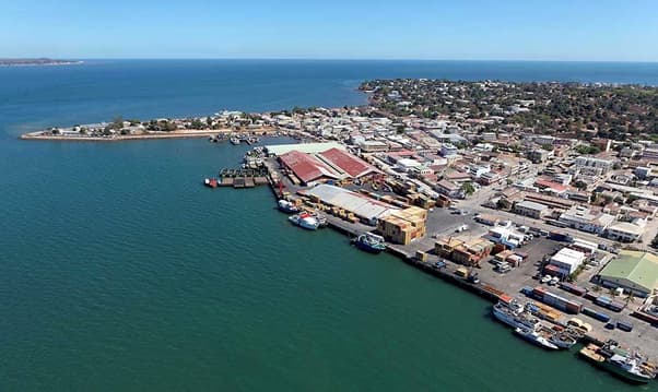
MAHAJANGA/MAJUNGA is located in East Africa, East Africa in Madagascar. UN/Locode* : MGMJN MMSI MID code: 647 Geographical coordinates: Latitude: -15.7219563 Length: 46.3145828 Mahajanga Boulevard Point Carré Capitainerie du Port B.P. 36 GSM : + 261 32 11 257 44 Mahajanga is a port city on the northern coast of Madagascar. You can see palm trees and food stalls facing the sea, La Corniche. The long coastline invites you to a city promenade surrounded by restaurants, including Plage du Grand Pavois. Tourist sites like the Cirque Rouge are a canyon with impressive red cliffs. Across Bombetoka Bay, the lighthouse in Katsepy village offers panoramic views. Setting up fuel pipeline: administrateur@logpetro.com 0320537934 Steering/boatage smoi.mar@wanadoo.mg ger@smoi.mg 0202245156
Servizi
Port Information
Telefono
Berth Sizes
Profondità alla Bassa Marea Media
Manovrabilità
Porto di Entrata
Overseas Visitor Berths
Tipo di Molo
Tidal Flow
Active Winter
Weather Forecast
 Light and variable.
 Increasing from 21 to 25°C
 Calm sea
 UV Index: 3 - Moderate
 Sunny
Sunny
- S 3–6 knots veering W 3-6 knots.
- Increasing from 25 to 30°C
- Calm sea
- UV Index: 7 - High
- Sunny
- W 3–11 knots.
- 26 to 31°C
- Calm sea
- UV Index: 7 - High
- Sunny