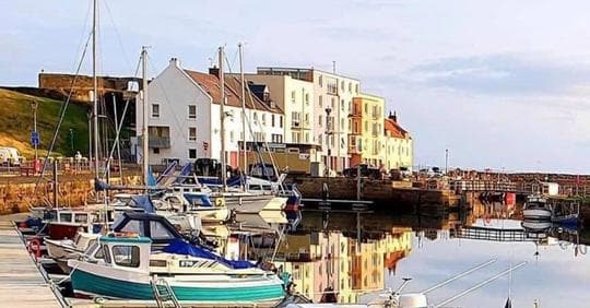
St. Andrews Harbour
Facilities & Weather Forecast


St. Andrews Harbour
Marina in United Kingdom
St Andrews Harbour is a tidal port located at the mouth of the Kinness Burn, supporting both fishing and leisure activities. It is managed by the St Andrews Harbour Trust and offers visitor moorings, a slipway, and community-focused amenities. Ownership: Fife Council Management: St Andrews Harbour Trust Usage: Leisure, Fishing (municipal harbour) 🛠️ Facilities & Services Slipway Access (Harrow):
Show More
St. Andrews Harbour Installations
Électricité
Eau
Toilettes
Nourriture
Supermarché
Installations médicales
Essence
Diesel
Recyclage
Bar
Blanchisserie
Marchés
Dédouanement
56.33942 N, -2.78396 E
St. Andrews Harbour Information
Manœuvrabilité
Fair
Approches et balisage des canaux
Poor
Type de quai
Fixed
Profondeur à la marée basse moyenne
< 2m
Courant/flux de marée
Beware
Port d'entrée
Yes
Amarrages pour visiteurs
Yes
Téléphone
07506 409792St. Andrews Harbour Weather Forecast
Tue
5AM - 9AM
30 December 2025
- N 9 knots decreasing to 7 knots.
- 2°C
- NE 0.6m at 7s period
- UV Index: 0 - Low
- Sunny
Tue
9AM - 1PM
30 December 2025
- N 4–7 knots backing W 4-7 knots.
- 2°C
- NE 0.6m at 7s period
- UV Index: 0 - Low
- Sunny
Tue
1PM - 5PM
30 December 2025
- W 6 knots.
- 0 to 3°C
- NE 0.5m at 7s period
- UV Index: 0 - Low
- Sunny


Obtenez plus d'informations et des prévisions météorologiques précises.
Téléchargez l'application PredictWind pour des prévisions météorologiques de premier plan et des informations sur votre prochaine destination, y compris les emplacements marins, les commodités, les activités, les attractions, les dangers locaux et plus encore.