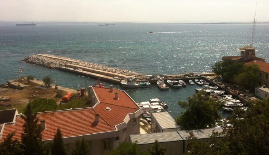
Predictwind Logo

SEDDÜLBAHİR FISHING HARBOUR

Marina Image

SEDDÜLBAHİR FISHING HARBOUR

Marina in Türkiye

Seddülbahir, meaning "Key of the Sea" is a village at Cape Helles on the Gallipoli peninsula in Turkey. The village lies east of the cape, on the shore of the Dardanelles. SHELTER Capacity : 50 boats Main Breakwater : 87 m Harbour Facilities Electricity Drinking Water Fuel Station Telephone Net Repairing Area Administration Fish Market Administration : Seddülbahir Village Headman

1 Rating
View Website
Facilities
icon
Electricity
icon
Petrol
icon
Water
icon
Markets
icon
Showers
icon
Toilets
40.04198 N, 26.18988 E
Info
Active Winter Community?

Yes

Manoeuvrability

Tight

Approaches & Channel Marking

Fair

Dock Type

Fixed

Depth at MLW

< 2m

Current/Tidal Flow

Negligible

Visitor Berths

Yes

VHF Channel

16

Weather
Sun
5AM - 9AM
08 September 2024
  • wind icon
    NE 15–18 knots. Gusts up to 21 knots.
  • temp icon
    22°C
  • wave icon
    N 0.8m at 3s period
  • sun icon
    UV Index: 0 - Low
  • rain icon
    Sunny
Sun
9AM - 1PM
08 September 2024
  • wind icon
    NE 14–18 knots.
  • temp icon
    Increasing from 22 to 25°C
  • wave icon
    N 0.8m at 4s period
  • sun icon
    UV Index: 6 - High
  • rain icon
    Sunny
Sun
1PM - 5PM
08 September 2024
  • wind icon
    N 17 knots decreasing to 14 knots. Gusts up to 20 knots.
  • temp icon
    26°C
  • wave icon
    N 0.7m at 3s period
  • sun icon
    UV Index: 6 - High
  • rain icon
    Sunny
local knowledge on phone

Get more info and accurate weather forecasts.

Download the PredictWind App for world-leading weather forecasts and info on your next destination including marine locations, amenities, activities, attractions, local hazards and more.

Explore other Marinas in Canakkale

GELİBOLU FISHING HARBOUR

Marina in Canakkale
Gelibolu, also known as Gallipoli "beautiful city"), is the name of a town and a district in Çanakkale Province of the Marmara region, located in Eastern Thrace in the European part of Turkey on the southern shore of the peninsula named after it on the Dardanelles strait, 2 miles away from Lapseki on the other shore. The port of Gelibolu lies on the N shore of the Dardanelles, 3 miles W of the entrance to the Sea of Marmara. Gelibolu is well known for sardine canning. HARBOUR It is inland shelter. Water area is 850 m2. Anchorages There are two possible berthing areas for yachts. The eastern corner of the commercial harbour is one, and just inside the fishing harbour is the other. In each case care should be taken with the depths. There is good shelter from the wind in both harbours. It is also possible to anchor to the east of the harbour. There is good holding in the sand and shelter from the prevailing wind. The northern side of the commercial harbour has now been dredged but there are no mooring facilities on the quay. The fishing harbour has also been dredged and it is possible to berth bows-to in front of the restaurant. This is a busy harbour and care needs to be taken to avoid the many ferries and fishing boats. It is possible in settled weather to anchor close inshore just W of the harbour. However, this should only be attempted in settled weather as it is a very uncomfortable spot in even moderate winds. Gelibolu Port Gelibolu, which used to be a useful port of call for yachts transiting the straits, is now closed to yachts since the opening of the harbour of Lapseki on the southern shore directly opposite. Yachts are forbidden to moor at Gelibolu harbour. Moorings : 85 boats Draught max : 5 m Length max : 13 m SHELTER SERVICES Drinking water Bar/Restaurant Harbor Master Electricity Type: 220V Fuel Pump Fish Market Administration : Gelibolu Harbor Master
View Details